Heavy rain and storms resulting in flooding, have increased significantly in recent years. When large quantities of rainfall in very short periods of time, masses of water overrun sewage capacities in many areas and allow water bodies to rise over their banks, often with destructive force and disastrous effects. Emergency responders on scene, then face the task of coordinating aid and protection measures as efficiently as possible. However, affected areas are often inaccessible, and situations are unwieldy. Real-time data and images from the air, combined when possible with further sensor data on the ground’s condition, for example, would provide emergency responders with valuable information and allow them to intervene where it would be most prudent.
Engineers Martin Becker, Simon Batzdorfer and Markus Bobbe of the Institute of Flight Guidance at the Technische Universität Braunschweig (TUBS) and Jan Schattenberg, Hannes Harms and Julian Schmiemann from the Institute for Mobile Machines and Commercial Vehicles, also at TUBS have taken up this topic and developed an automated exploration system. The DLR Space Administration was promoting the engineers’ project with approximately one million euros funding from the Federal Ministry of Economics and Energy, to work on an exploration system in cooperation with AirRobot GmbH & Co. KG from Arnsberg, Germany. Generating aerial recordings in catastrophe-stricken areas such as flood zones, using automated unmanned aircraft plays a meaningful role in the exploration system. Combined with ground-based systems, information regarding the situation in affected areas can be collected to support emergency responders at the affected location. All data collected from aerial and ground units can then be represented within a single map and made available to emergency response personnel.
High-resolution aerial images for rapid aid
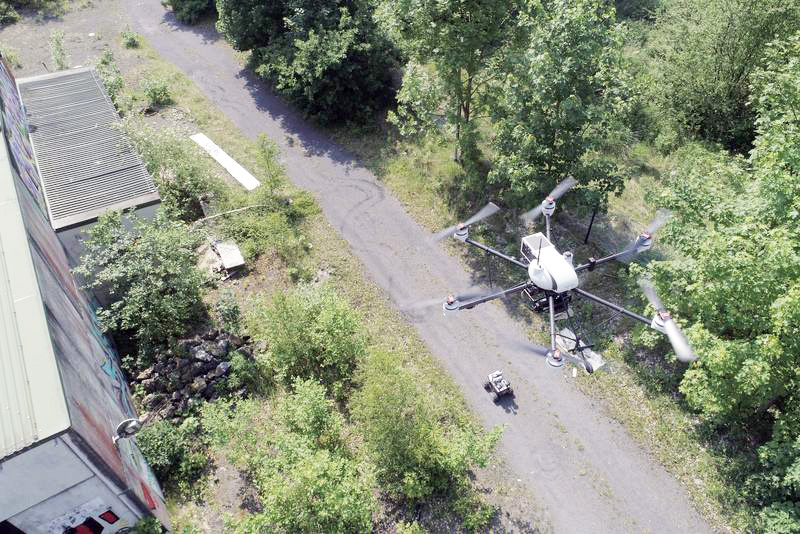
A Manta camera from Allied Vision onboard the drone Hugin delivers images from the air. The project team chose the drone’s name deliberately; in Norse mythology,
The Manta camera combines high resolution with low weight, factors that mattered to the system’s developers. Hugin should carry as little additional weight as possible, to minimize the interference on the operation time. Depending on the external conditions, Hugin can remain in the air for up to 30 minutes without recharging. Secure communication via its command link, is guaranteed within a range of a kilometer. Equipped with a control system based on positional data, the drone is able to safely navigate a predefined route, even in challenging environmental conditions and with peak win loads, at up to 12m/s.
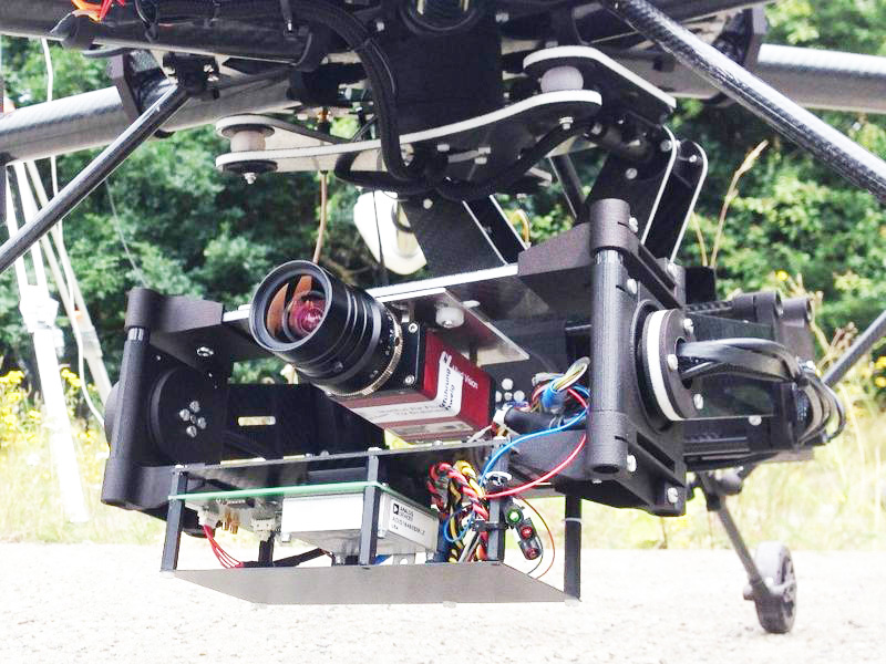
During the flight, individual images are recorded from altitudes of usually 100 meters, depending on the application. All obtained images are then processed to generate a continuous overview of the entire application area. Due to the automatic exposure adjustment functionality of the camera, even changing light conditions are manageable. Since comprehensive image preprocessing (i.e., image optimization, light correction, white balance, color correction, binning, decimation) takes place within the camera, information-rich two-dimensional images are transmitted to the base station, located on the ground. In addition, a self-developed local communication network is used, which enables targeted information exchange, based upon different communication technologies. During catastrophic events, emergency responders can evaluate the situation better and more quickly with the aid of these images. Since they can see where protective measures must be taken or increased, they can initiate the necessary steps.
In case of emergency, system operation must be fast and intuitive. The system determines the flight path based on just a few parameters, so that the emergency services have as little effort as possible to control the drone. The response team leader can easily choose the area to fly over at the system’s ground station. Flight planning then is automatically performed, incorporating all mandatory parameters e.g., opening angle of the lens, to ensure a minimal defined overlap for photogrammetric processing of the obtained images. The drone follows the flight path automatically, and the (live) evaluation of the images is subsequently triggered automatically, too. Within the ground station, the user can specify the actually piloted drone and to select data streams, which are then provided in real time including aerial imaginary or other sensor data.
Successful tests in practice
The Stadtentwässerung Braunschweig GmbH was confronted with serious flooding in the summer of 2017 and urgently needed information on current water levels near the Okerriver’s course through the city. They requested help from the TU Braunschweig via an existing contact at the Braunschweig fire department. One particularly endangered area (from the Eisenbütteler Wehr to the Volkswagen Halle) was surveilled and documented in a variety of aerial images. The Stadtentwässerung thus gained knowledge not just about how the flooding had spread, but could also retrace whether protective measures undertaken during the prior flooding in 1994 were now successfully taking hold.
Based on the images, important decisions could be made, and questions answered such as – must warnings be issued, are closures required, at which locations are sandbags necessary, and via which routes are these regions even accessible? In the future, the Braunschweig Stadtentwässerung would also like to take advantage of the Braunschweig TU system for long-term observation of flood protection measures and to review prognosis models.
In another application case, the Braunschweig TU research team successfully tested Hugin in the field of coastal protection. On the East Frisian island of Langeoog in the southern North Sea, a flyover produced revealing aerial images of dunes and dykes. One item that drew particular attention was a beach nourishment taking place at the time. During one flushing procedure, numerous aerial images were made of the location that clearly demonstrated to local coastal protection authorities just how close the tide came to the dunes in the still unfinished area of the beach nourishment, and in the same moment, how far the surge was removed from the dunes when the beach level had been raised by additional sand.
The TU Braunschweig engineers are already considering other applications and further constraints. Thus, the drone can be equipped with a thermal imaging camera, for example, to be able to find injured persons in the dark.
![]()